
本文
Mountains and Waterfalls
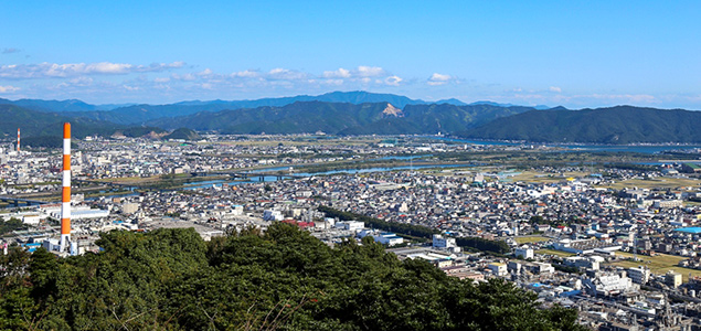
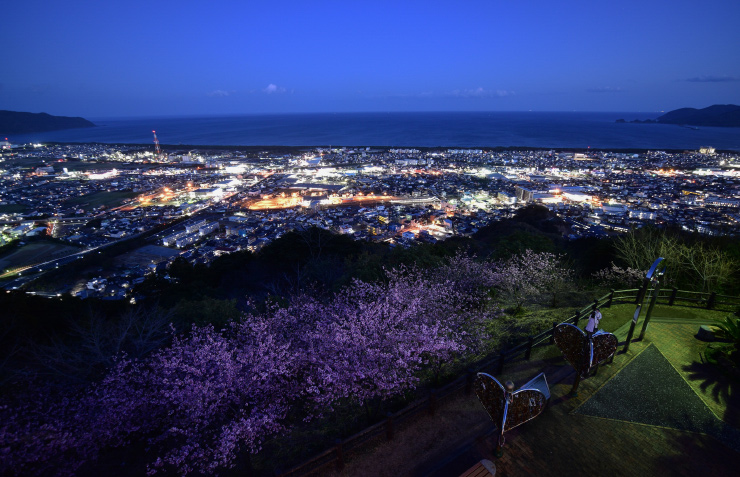
Mount Atago
Mount Atago is located in the central part of Nobeoka City, 251 meters above sea level. From the observatory near the mountain's summit you can enjoy sweeping views of the city's urban area, as well as Hyuga-nada sea. On a clear day, you can also see Shikoku Island in the distance. The night view from this point has been recognized as one of the "Japanese Night View Heritage Sites," the only such site of its type to be recognized in Miyazaki Prefecture.
Access
Approximately 20 minutes by car from JR Nobeoka Station to the parking area of the observatory.
Japanese name: Atago-yama (愛宕山)
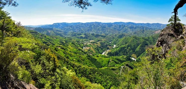
Mount Okue
At an altitude of 1,644m, Mount Okue is the featured mountain of the Sobo Katamuki Quasi-National Park, known for its unspoiled natural features. The park is covered with primeval forests of Japanese hemlocks, beech trees, and Japanese white pine. A large range of granite mountains known as "Hoko Peak," "Mount Hiei," “Yahazu Peak," and “Mount Mukabaki," surround Mount Okue.
Many rare plant species can be found along the trails and visitors can enjoy the magnificent colors of every season. For example, Akebono azaleas bloom in spring and the colored leaves in autumn are spectacular. Many mountain climbers from both inside and outside Miyazaki Prefecture visit the area.
Part of the Sobo Katamuki Quasi-National Park is the Houri River ravine, which originates from Mount Okue and the nearby mountains. The area along the upper ravine of the Houri River is a designated protected area, with a rare breed of bamboo (found in only 3 places in Japan, including the Houri River area) growing in the wild.
Each year, the number of hikers and mountaineers visiting Mt. Okue totals around 20,000, including regulars who are drawn to the charms of the mountain from season to season. We advise beginners to climb with an experienced companion or a guide as the standard trail takes 8 to 10 hours to hike and some parts of the trail, which includes the use of ladders and ropes, are very difficult to climb.
Access
Approximately 2 hours by car from JR Nobeoka Station to the trailhead.
Japanese name: Okue-yama (大崩山)
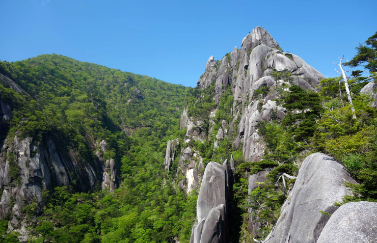
Hoko Peak
Located in an unexplored region of captivating natural beauty, Hoko Peak is 1,277 meters above sea level. Like Mount Okue, it is also designated as part of the Sobo Katamuki Quasi-National Park, and is formed by granite. The granite monolith, reaching as high as 350 meters, is one of the largest of its size in Japan. It is also recognized as a noted rock climbing spot.
Access
Approximately 80 minutes by car from JR Nobeoka Station to the trailhead.
Approximately 1 hour 30 minutes from the trailhead to the top of Hoko Peak.
Japanese name: Hoko-dake (鉾岳)
Mount Hiei
Mount Hiei is 918 meters above sea level. The mountain, which was designated as a place of noted scenic beauty by the national government in 1939, is a range of monolithic granite, with an extensive view like that in a Chinese-style landscape painting. It is also well-known as a prominent rock-climbing spot, attracting climbers from all over Japan. It takes one hour on foot from the trailhead to the first observation point, and an additional hour from there to the mountain's summit.
Mount Hiei is part of the Okue Mountain Range, which emerged due to the uplift and erosion of a dike that was formed underground by volcanic activities. At the Sobo Katamuki Quasi-National Park, you can see large granite porphyritic dikes such as Mount Hokodake, Mount Hiei, Mount Yahasudake and Mount Mukabaki, which surround Mt. Okue.
Access
Approximately 50 minutes by car from JR Nobeoka to the trailhead.
Japanese name: Hiei-zan (比叡山)
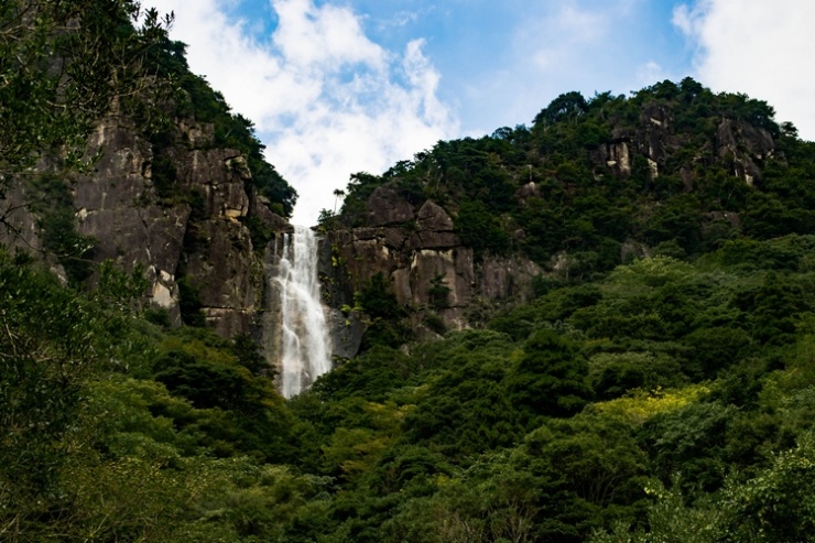
Mount Mukabaki and Mukabaki Falls
Mount Mukabaki is formed by two ridges. The right peak is known as Medake, the "female peak," and the left peak, the higher and most commonly climbed of the two, is known as Odake, the "male peak." Mukabaki Falls flows through these two peaks. The waterfall is approximately 77 meters high and 30 meters wide. The magnificent view of the waterfall, which can be seen from the mountain trail, is loved by many citizens and mountain climbers. It takes about 2 hours to hike to the summit.
The "Mukabaki Children's Nature Center" with an astronomical observation dome and Hideji Brewery are located at the foot of the mountain.
Access
About 25 minutes by car from JR Nobeoka Station to the trailhead. From there, it takes about 60 minutes to hike to Mukabaki Falls and another 60 minutes from the falls to the summit.
Japanese name: Mukabaki-yama (行縢山)
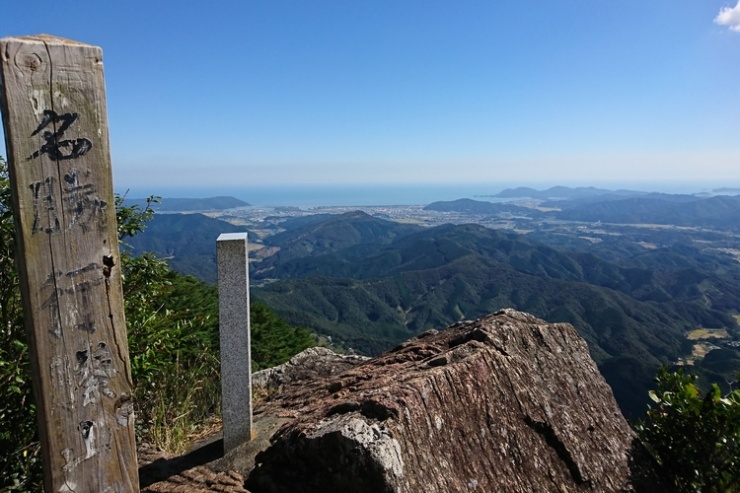
Mount Kagami
If you cast your eyes down from the peak of Mount Kagami, you will see the Nippo coastal scenery spread out magnificently, as well as the mountains of Sobo Katamuki Quasi-National Park to the West. On days with good wind, you might be able to see paragliders flying around the the summit of Mount Kagami.
Access
Approximately 30 minutes by car from Kitagawa General Branch Office to the summit.
Japanese name: Kagami-yama (鏡山)
Kurouchi Falls
With its clear waters falling from a height of 30 meters, the Kurouchi Falls in Kitagawa are sandwiched between untouched forests of beech and evergreen oak and a ridge of mountains, forming an area of superb natural beauty.
Access
Approximately 40 minutes by car from JR Nobeoka Station to the Kurouchi Falls.
Japanese name: Kurouchitani (黒内谷)
Koukadani Kannon Falls
The Koukadani Kannon Falls is a dual-level waterfall with a height of 75 meters and a width of 10 meters, located 2km down Route 326 in Shiraishi in Kitagawa. The waterfall basin, sculpted perfectly over the years by the passage of water over stone, will leave the viewer in awe.
The Story of the Koukadani Kannon Falls
The following information about the origin of Avalokitesvara (Buddhist deity of children and childbirth) has been kindly contributed by Mr. Takeru Ono of Fukazaki, Kitagawa.
Sometime in the Edo period (1600-1868), in order to save time and labor, a charcoal prospector threw charcoal logs into the mountain streams above the falls. However, they all got trapped in the basin underneath the waterfall and not even one log was washed down the river. The prospector then apologized to Kannon, the Buddhist deity of mercy, and with an instant thunderous roar, they say that the charcoal logs fell and flowed down the river. According to this legend, it is thought that Kannon has been worshipped since before the Edo period.
The waterfall is split into two levels. Half-way between the 1st and 2nd level, there is a deep basin containing a shrine where Kannon is worshipped. Blessings were given in the form of lucky charms for protection against epidemics and infectious diseases amongst children like dysentary.
Originally residents of the 6 arches of Nekodani and Nagaharu worshiped at this site, but as the waterfall's beauty became more wellknown, many worshippers came from outside the community. In 1928, when the Showa Emperor was enthroned, the village celebrated the state ceremony with several days of holiday and the 16 districts within the village planned a joint costume-parade and play which was held at the falls. In spite of food shortages, the villagers did their best and continued the event until it came to an end during wartime.
Temple Festivals
- Festival on the 17th of the 3rd month of the lunar calendar. Fathers went alone to the shrine and made offerings like rice wine, candles, sweet dumplings, and prayed that their children would not catch any illnesses.
- Festival on the 17th of the 7th month of the lunar calendar. Mothers would take all of their children along with them to the shrine. They would make offererings like rice wine, candles, incense, sweet dumplings, vegetables, and young persimmons and pray that their children would not catch any illnesses. Afterwards, they would spend a pleasant evening together enjoying the leftovers from the offerings made to the gods.
Access
Approximately 35 minutes from JR Nobeoka Station to the Koukadani Kannon Falls and approximately 20 minutes from the Kitagawa General Branch Office by car.
Japanese name: Koukadani Kannon (香花谷観音滝)
Nachi Falls
Nachi Falls is located inside Nyoirinji Temple grounds and is 20 meters in height. The waterfall is registered as a noted scenic beauty spot in Miyazaki Prefecture.
Access
Approximately 25 minutes by car from JR Nobeoka Station.
Japanese name: Nachi No Taki (那智の滝)
Moriya Kanon Falls
With its clear waters falling from a height of 23 metres, this waterfall is located between forests of beech and evergreen oak, and a ridge of mountains. Moriya Kannon Hall, a peaceful place where local residents can gather, is located in the center.
Access
Approximately 25 minutes from JR Nobeoka Station.
Japanese name: Moriya Kanon Taki (森谷観音滝)
Kanon Falls
The Kanon Falls consist of two waterfalls which run from a height of approximately 8 metres, as if competing with one another. There is a maintained walkway that goes to the basin of the waterfall.
Access
Approximately 40 minutes from Nobeoka City Center.
Japanese name: Kanon Taki (観音滝)
Futamata Double Falls
Futamata Double Waterfall is 30 meters high and 20 meters wide. At this waterfall, you can enjoy viewing natural figurative arts created by nature.
Access
Approximately 50 minutes by car from JR Nobeoka Station.
Japanese name: Futamata Nidan Taki(二股二段滝)

 <外部リンク>
法人番号6000020452033
〒882-8686 宮崎県延岡市東本小路2番地1
電話 0982-34-2111(代表)
Copyright © Nobeoka-City All Rights Reserved.